


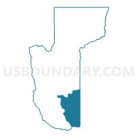
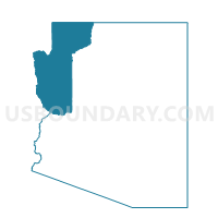
Wikieup Voting District, Mohave County, Arizona
About
Outline

Summary
| Unique Area Identifier | 525079 |
| Name | Wikieup Voting District |
| County | Mohave County |
| State | Arizona |
| Area (square miles) | 1,327.88 |
| Land Area (square miles) | 1,327.03 |
| Water Area (square miles) | 0.85 |
| % of Land Area | 99.94 |
| % of Water Area | 0.06 |
| Latitude of the Internal Point | 34.73942970 |
| Longtitude of the Internal Point | -113.46403570 |
Maps

Graphs
Select a template below for downloading or customizing gragh for Wikieup Voting District, Mohave County, Arizona


Neighbors
Neighoring Voting District (by Name) Neighboring Voting District on the Map
- Alamo Voting District, La Paz County, AZ
- Bagdad Voting District, Yavapai County, AZ
- Congress Voting District, Yavapai County, AZ
- East Kingman Voting District, Mohave County, AZ
- Hualapai Voting District, Mohave County, AZ
- Oatman Voting District, Mohave County, AZ
- Sara Voting District, Mohave County, AZ
- Seligman 2 Voting District, Yavapai County, AZ
- Yucca Voting District, Mohave County, AZ
Top 10 Neighboring County Subdivision (by Population) Neighboring County Subdivision on the Map
- Prescott CCD, Yavapai County, AZ (119,809)
- Kingman CCD, Mohave County, AZ (66,268)
- Bullhead City CCD, Mohave County, AZ (65,938)
- Lake Havasu City CCD, Mohave County, AZ (57,129)
- Parker CCD, La Paz County, AZ (20,489)
- Congress CCD, Yavapai County, AZ (9,623)
- Ash Fork CCD, Yavapai County, AZ (2,349)
Top 10 Neighboring Place (by Population) Neighboring Place on the Map
Top 10 Neighboring Elementary School District (by Population) Neighboring Elementary School District on the Map
- Congress Elementary District, AZ (2,439)
- Wenden Elementary District, AZ (815)
- Yucca Elementary District, AZ (686)
- Owens-Whitney Elementary District, AZ (610)
Top 10 Neighboring Secondary School District (by Population) Neighboring Secondary School District on the Map
Top 10 Neighboring Unified School District (by Population) Neighboring Unified School District on the Map
- Kingman Unified School District, AZ (65,381)
- Bagdad Unified School District, AZ (2,143)
- Seligman Unified District, AZ (1,316)
Top 10 Neighboring State Legislative District Lower Chamber (by Population) Neighboring State Legislative District Lower Chamber on the Map
Top 10 Neighboring State Legislative District Upper Chamber (by Population) Neighboring State Legislative District Upper Chamber on the Map
Top 10 Neighboring 111th Congressional District (by Population) Neighboring 111th Congressional District on the Map
Top 10 Neighboring Census Tract (by Population) Neighboring Census Tract on the Map
- Census Tract 9548, Mohave County, AZ (7,012)
- Census Tract 14.03, Yavapai County, AZ (3,630)
- Census Tract 201, La Paz County, AZ (2,815)
- Census Tract 21, Yavapai County, AZ (2,349)
- Census Tract 13, Yavapai County, AZ (2,138)
Top 10 Neighboring 5-Digit ZIP Code Tabulation Area (by Population) Neighboring 5-Digit ZIP Code Tabulation Area on the Map
- 86401, AZ (24,289)
- 86305, AZ (17,356)
- 86337, AZ (1,267)
- 86438, AZ (913)
- 85357, AZ (761)
- 85360, AZ (222)